News
News Archive
- ‘Amid the Hills of Redesdale’ community radio play released!
- A Fantastic Year for Redesdale!
- Archaeological Excavation report produced for Bellshiel
- Archaeological Excavation report produced for Yatesfield enclosed settlement
- Archaeological Survey Report Published For Ancient Settlement At Rattenraw
The Liberty of Redesdale
August 10, 2022
The Liberty of Redesdale – but in Coquetdale
by David Jones
This article was kindly supplied by David Jones, Chair of the Coquetdale Community Archaeology Group to reproduce here.
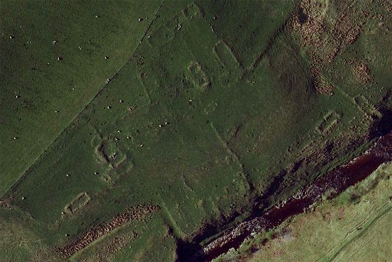
The Linbrig site (right)
As part of their structure of government, in the late 11th century the Norman kings of England started establishing Liberties, areas where they partly relinquished their all-powerful rights as monarchs in favour of a local lord. One of these was the Liberty of Redesdale.
This name conjures up images of the Rede Valley and the surrounding countryside, but the Liberty was larger than that, being essentially the region on either side of Dere Street that controlled access to and from Scotland. Its eastern boundary was in what we now think of as Coquetdale, and much of it ran along the south and west banks of the river Coquet, including places like Harbottle and Holystone. The Liberty lasted for over 400 years: for much of that time its Lords were the Umfraville family, and only in the Tudor period did the area become part of the Middle March.
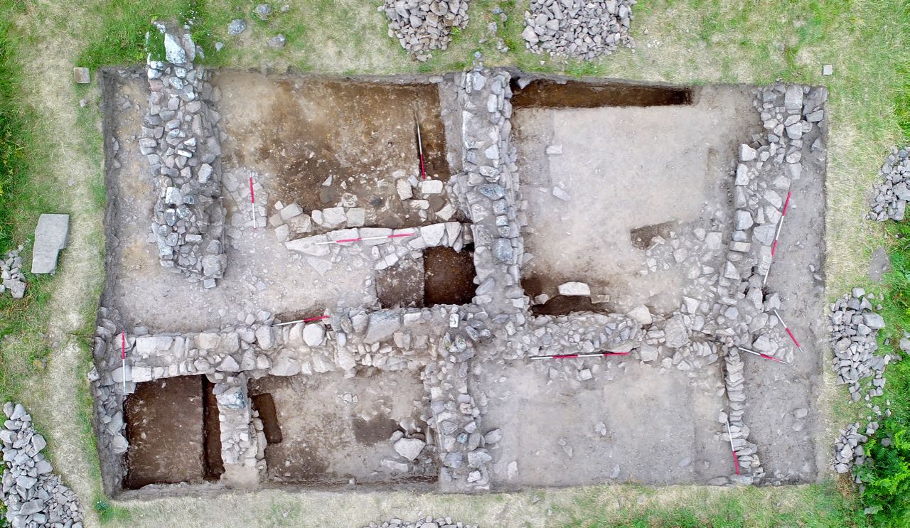
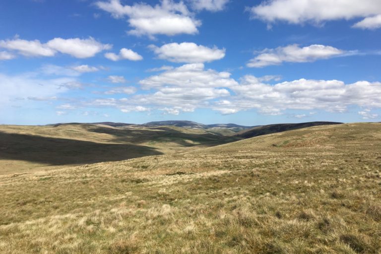
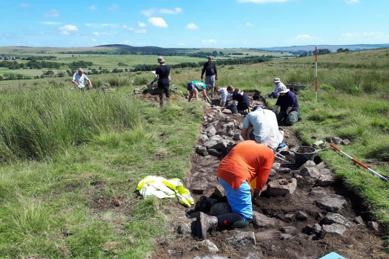
Since 2018, Coquetdale Community Archaeology (CCA) has been investigating a site lying in a bend of the Coquet at the extreme eastern edge of the old Liberty. About 4 km upstream from Alwinton and known as Linbrig, it’s on a farm called Linbriggs and consists of the remains of some 20 structures spread over a little over 1 ha. Somewhat misleadingly, it’s shown on maps as a Medieval Village: this is partly true – it’s certainly medieval – but there’s really little sign of any village-like structure or layout to the ridges and banks that mark buildings and yards. The site is scheduled, and so far three structures have been investigated. One is a grain drying kiln down by the river, while the other two are the remains of buildings that were originally robustly built houses but which seem to have been repurposed for agricultural activity.
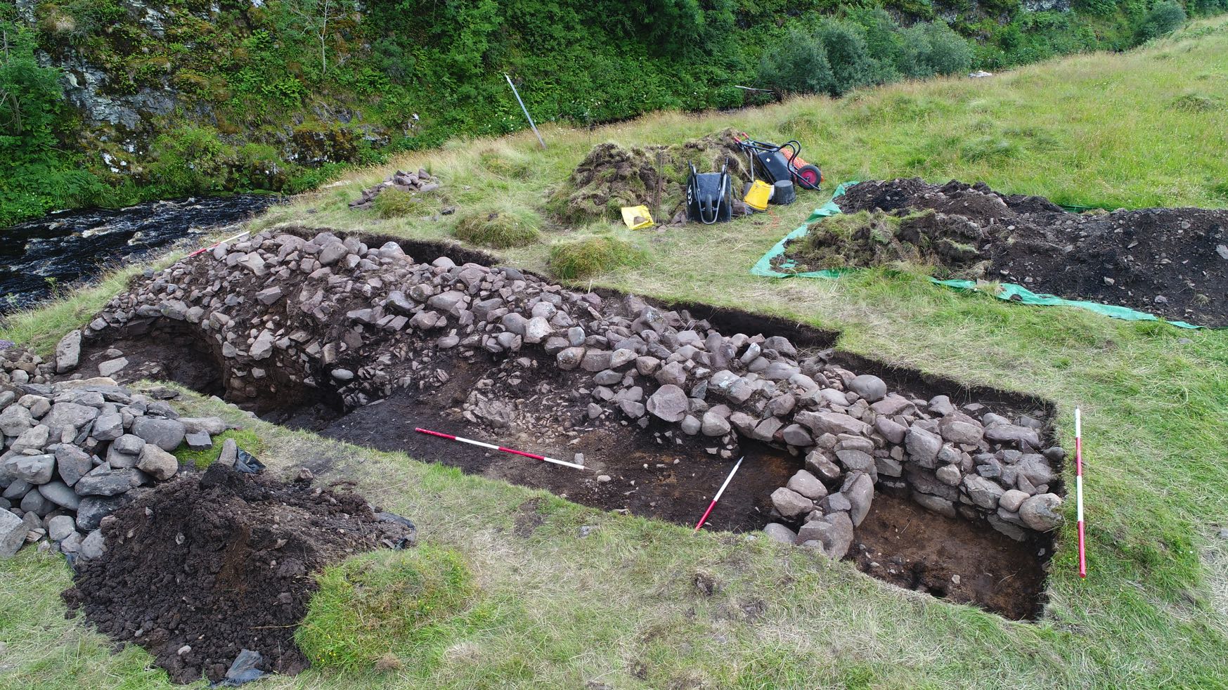
Post-excavation work on the kiln is continuing, but there is strong evidence that the fire that dried the grain was on the floor of the kiln itself, and not a short distance from it with hot air being delivered along a flue. Radiocarbon dates from charcoal both on and beneath the kiln floor show activity in the 14th century, and initial studies suggest that oats were the main crop being processed.
The first of the two other structures excavated was a rectangular building near the north-east end of the site, measuring 13 m by 6 m with walls up to half a metre high. These were robust, consisting of The kiln and adjacent buildings The Linbrig site a mixture of dressed blocks, more roughly-worked stone and some natural boulders. By the south-east wall were the remains of a collapsed gable: when reconstructed on the ground it revealed that it had incorporated a slit window with dressed surrounds. Pottery and radiocarbon dating showed activity in the 14th and early 15th centuries, and a number of building phases were identified, some probably after the building had fallen out of domestic use. For example, a cross-wall had been built on top of an earlier flagstone floor, blocking a doorway in the north-east wall.
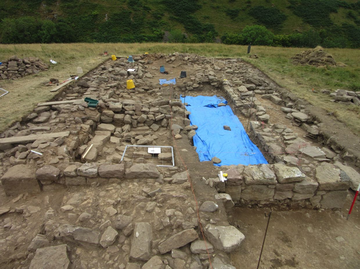
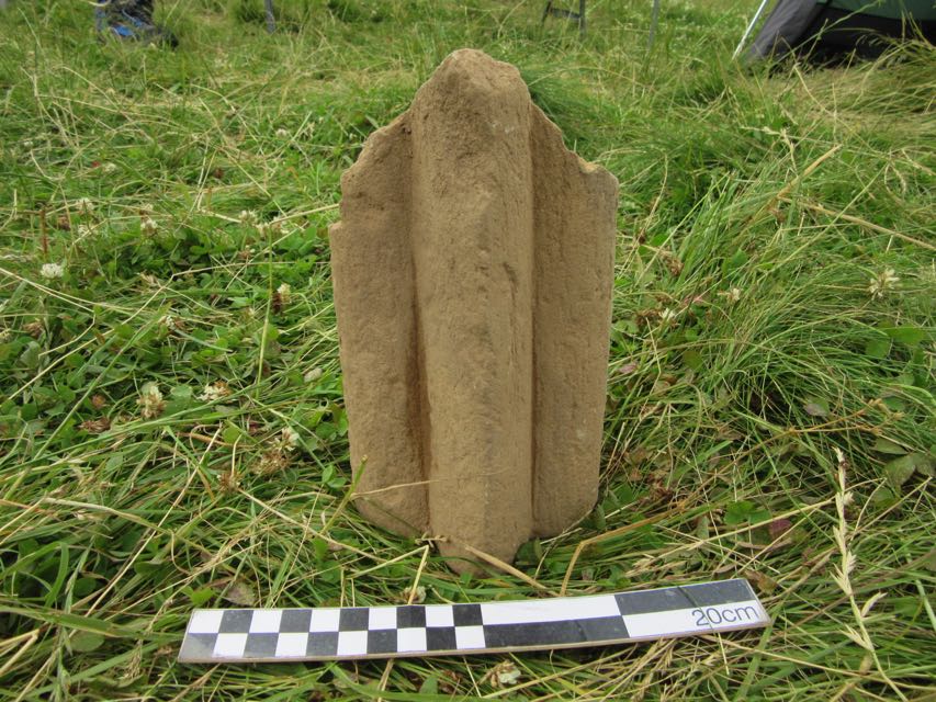
This doorway incorporated blocks that had clearly been re-used, and a lot of similarly earlier stone was identified elsewhere around the building. Some of the quoins were unexpectedly well-dressed, with chamfered corners, and other finds included a voussoir, a length of keel moulded stone and a decorated impost block from the base of an arch. Some of these have been identified as of 12th or 13th-century ecclesiastical origin. The third building, opened in 2021, is towards the south-west end of the site, and is more complex. Before excavation, the ruined walls appeared very substantial and suggested at least three adjoining structures, and after one season’s work we are starting to get some understanding of them.
The large amounts of pottery found suggests 14th-century domestic use, but the building had been modified with substantial later additions. In particular, the remains of some of the original medieval walls had been crudely built up by encasing them with quantities of earth and stone. And it’s possible that a substantial cross-wall is late as well. These changes may date from the late 17th century: post-medieval pot was identified in this wall and the remains of dateable tobacco pipes were found nearby, artefacts that are absent elsewhere on the site.
Interestingly, more dressed stone was found, including a chamfered block in one of the walls, part of a window arch and a large curved slab whose function is unknown. So an important question is where did this stonework come from? Some of the stones are portable, but others much less so. A quoin in the building at the north-east end of the site has been estimated to weigh some 750 kg. One possibility is that the source was the medieval church at Alwinton; this was nearly 5 km away by the likely course of the medieval road, which also involved a river crossing. Harbottle castle, which may have had a chapel, was still further away. But there is another, much closer, option.
A Patent roll, dated 25th September 1317, contains the following entry: Licence for the alienation in mortmain by Richard de Horsleye of a messuage, 100 acres of land, 6 acres of meadow, and 20s. of rent in Lynsheles, and Alwinton to a chaplain to celebrate divine service daily in the chapel of St. Nicholas in his manor of Aldensheles for his soul and the souls of his ancestors and all Christians.
This is the earliest identifiable reference to the name Aldensheles and the context suggests that it was somewhere to the west of Alwinton and perhaps in the Liberty of Redesdale. Later references confirm this. On June 5th 1325 an inquisition post mortem entry for Robert de Umframvill lists:
Aldenscheles. The manor held by John de Horsely by service of 1/5 knight’s fee, now worth nothing [by devastation of the Scots]
This sacking of the manor may have been the end of the chapel, because it’s never mentioned again. Later references to the manor identify the Horselys as holding it up to the middle of the 16th century at which point a marriage meant it was transferred to the Carnaby family. In 1663 there is an entry in a list of rates and rentals for Jane Carnaby as owner of Adon Sheeles al’s Quicking Court: for the first time this identifies exactly where the manor was.
Quicking Court – now Quickening Cote – is a still-extant farm on the western boundary of Linbriggs, the farm with the Linbrig site. But the boundary between them has moved relatively recently. An 1846 tithe map shows that Quickening Cote’s land then extended right up to the river Coquet, just like the medieval Liberty, and included the Linbrig site. The boundary change happened in 1911, when the War Office purchased most of Quickening Cote to be part of the Redesdale ranges and transferred an unwanted eastern area of the farm to Linbriggs.
This means that the site CCA has been investigating was once on the manor of Aldensheles, and careful examination of LiDAR and aerial photographs suggests that it was the major settlement there. The group of structures by the Ridlees Burn which is currently (and, we think, wrongly)
known as Aldensheles appears to be little more than a set of shielings and agricultural enclosures.
But we don’t yet know where the Aldensheles chapel was, or if it was on the Linbrig site at all. There is no east-west aligned ruin there, but some local churches (e.g. Holystone) are skewed by almost 20° and the ruined church at Mow in the north Cheviots was some 30° astray. A resistivity survey of the central part of the Linbrig site shows nothing new there. But there is one final intriguing observation. In 1903 a visitor to the area reported that the Linbrig site was being used by farmers as a source of dressed stone, and that local people called it Aydon Sheles or Aydonsheles Kirk. Written records show Aldensheles was still being used as an alias for Quickening Cote in the 1730s, and folk memory can last for hundreds of years.
Was that the case in Coquetdale?
Leave a Reply